Living with Lions in the Urban Wildland Interface
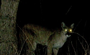
From the point of view of a mountain lion, Knowland canyon sits at a key crossroads: to the north and south are the East Bay Regional Park District’s ridgeline parks extending in a nearly unbroken 25-mile chain from El Sobrante south to San Leandro. To the east is San Leandro Reservoir and to the west is Knowland Park. These north-south and east-west axes afford mountain lions critical migratory corridors of sufficient size to accommodate portions of their large home ranges.
Like other locations around the region, the East Bay hills have seen a rise in sightings of mountain lions (also known as cougars or pumas) in recent years. While these may seem like random and isolated events, they are actually part of a change in pattern that wildlife biologists have begun to study and document. According to wildlife biologist, Jim Hale, the mountain lions are following their favorite prey, the black-tailed deer. He surmises that a large portion of the deer population has migrated westward across the hills in response to the succulent vegetation found in abundance in private gardens and public parks.
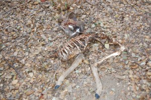
The canyon including Knowland Park is one such key location. Carcasses of deer killed by mountain lions have been found in back yards in Knowland canyon and in the park by Hale, who has been documenting the movement of these large cats throughout the Bay Area for many years. The photo shows a deer carcass, the remains of a mountain lion kill found this year less than 50 feet from the proposed site of the Interpretive Center of the zoo expansion project. Perhaps because it is a city park unknown and unlisted, Knowland Park has not been on the radar screen for its role in helping to maintain this top predator. In fact the general study of how wildlife is using the urban wildland landscape fragmented by development has only really begun in earnest quite recently.
The Role of Top Predators in Healthy Ecosystems
In 1969 Dr. Joe McBride of UC Berkeley completed his doctoral dissertation that described a landscape level of change that he had observed while studying the process of plant succession in the East Bay hills: live oak woodlands succeeding to bay laurel trees. (1) The key factor was the absence of apex or top predators which historically kept in check the black-tailed deer that preferred to feed on acorns and oak seedlings. Without the mountain lion controlling the deer population, bay laurel could out- compete the oaks. Although McBride’s work was of interest to botanists and plant ecologists, it was at best a footnote for wildlife biologists.
Much more recently, researchers have begun to explore other ripple effects through ecosystems caused by the absence of apex predators. One such impact is the phenomenon of mesopredator release. Mesopredators are intermediate size carnivores such as coyotes, bobcats, skunks, raccoons, foxes, opossums, and feral cats that occupy the “middle” of the food chain.
In 2009, researchers described how ecosystems and natural communities are destabilized by the increasing populations of mesopredators that are unleashed from predation and competition when apex predators such as wolves, bears, and mountain lions are no longer present. (2) Without the apex predator, prey populations including songbirds, small mammals, and reptiles and amphibians are decimated by mesopredators, especially in urban wildland areas where human habitation provides food and shelter to them. In a recent article, Bay Nature explored the topic of mesopredator release in the Bay Area. (3) Of all mammalian top predator species that once existed in the Bay Area, only mountain lions are able to co-exist here today with human beings.
For those who may feel a little nervous at the thought of mountain lions so nearby, it is important to know that mountain lions prefer to avoid humans whenever possible. The chances of being attacked by a mountain lion are far less than the chances of being struck by lightning. Mountain lions are solitary creatures that move and hunt quietly and keep themselves and their young well-hidden. Bears, by comparison, are a much greater threat near human habitation, as they are more likely to get into garbage and create problems with aggressive behavior.
Why Knowland Park Should Be Protected as Part of a Regional Network
Knowland Park’s diverse and relatively intact native plant communities, including the rare chaparral and native grasslands, coastal scrub, oak woodlands, and riparian corridor of Arroyo Viejo watershed, which themselves are intrinsically worthy of protection, also provide an array of wildlife habitat. In addition to the mountain lions and mesopredators mentioned above, there is a rich array of amphibians, lizards and snakes, (including the state and federally-listed Alameda whipsnake) found in the grasslands, chaparral and creeks. Smaller mammals such as wood rats, mice, voles, moles, shrews, brush rabbits, and pocket gophers provide an abundant prey base, and diverse songbirds and raptors forage in the park.
Knowland Park is a stunning example of the opportunity to protect, conserve, and study a rare resource. Protecting the park also serves the wider regional conservation interests. Last year the Bay Area Open Space Council released “The Conservation Lands Network,” a landmark effort to prioritize protection of the Bay Area’s remaining open space lands to create a network of habitat sufficient to support the existing native flora and fauna. (4)
Mountain lions were chosen as one of the focal species because their large habitat requirements help organize planning on a landscape level. They are also an important conservation target: California is the only state to grant fully protected status to the mountain lion.
Key to the network’s success in this fragmented landscape is the concept of critical linkages between large landscape blocks of habitat like the East Bay hills. A second study to be released this spring highlights where corridors such as the one that links Knowland Park to Chabot Park and beyond to San Leandro Reservoir connect to even larger areas of habitat like Mount Hamilton so that they may remain open and protected.
According to the Conservation Lands Network report, “All local population estimates [of mountain lions] are well below thresholds for environmental variability, and many are well below thresholds for genetic and demographic issues. “(pg.119) In other words, in order for the Bay Area’s reduced populations of mountain lions to remain healthy, they must be able to connect with larger populations to prevent inbreeding and increase genetic variability.
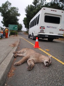
While no one knows yet how large a population exists in the East Bay Hills, there is no uncertainty about the need to keep corridors open and protected. The CLN concludes, “The potential for small population sizes makes it imperative that any mountain lion subpopulation is connected to others by dispersal.”(pg. 119) In other words, developing, fencing, and blocking off these key habitat areas poses unacceptable risks to the survival of mountain lions and other wildlife species in the Bay Area. When safe corridors are reduced or closed, mountain lions are often forced into crossing highways at their own peril. The accompanying photo shows a young male lion hit and killed on Highway 13 a few miles from Knowland Park last summer.
Increasingly, public agencies are recognizing their role in helping keep corridors open. A few years ago the Board of Directors of the East Bay Regional Park District voted to re-locate a large group campground planned for Sibley Regional Preserve when the public pointed out that the campground would affect critical access for animals using the Caldecott Wildlife Corridor which links the middle and northern sections of the East Bay hills.
We believe the City of Oakland and the Oakland Zoo should walk the conservation talk and face their responsibility to protect Knowland Park. The large perimeter fence that would surround the zoo’s proposed ridgeline development expansion area cuts through critical areas of the chaparral and oak woodlands which provide cover and safe passage for mountain lions and other wildlife species. Better expansion alternatives exist.
Dividing Knowland Park for whatever reason is contrary to the vision and goals of conservationists working today. Now more than ever conservationists, especially those working in urban areas, must examine how the part fits within the whole and fight to preserve what is left of our natural heritage.
1. McBride, Joe. Plant Succession in the East Bay Hills. Ph.D. Dissertation. University of California at Berkeley. 1969.
2. Prugh.et al. BioScience, Vol. 59. No. 9 October 2009, pp. 779-791.
3. Martin, Glen. Small-Time Predators, Big-Time Impacts. Bay Nature July-September 2011.
4. Bay Area Open Space Council. 2011. The Conservation Lands Network (www.BayAreaLands.org): San Francisco Bay Area Upland Habitat Goals Project Report. Berkeley, CA. 2011.
Laura Baker is an environmental activist and former conservation chair of the East Bay Chapter of the California Native Plant Society. She holds an MA in ecology and systematic biology. Growing up in Missouri, she learned early that the cure for most ills rests in spending time out in nature. She wishes for every child to have the experience of wholeness that nature provides.
Laura’s Knowlander blog is dedicated to building an online library of the natural history of Knowland Park so that the public may enjoy the park for the natural heritage treasure that it is. Knowing the land is a never ending process of inquiry open to all. We welcome your comments, contributions, and photos.


 Follow


Pingback: Mountain Lions – An Inconvenient Truth | Save Knowland Park()